As a history geek, I like to understand the story of a place, including all the people and events that came before me. While I like to think I have a good handle on Boston history, one of the areas I've never really understood is Beacon Hill: the neighborhood surrounding the Massachusetts State House. The Federal and Greek Revival style homes, brick sidewalks, gas lit street lamps, quaint alleyways - all nestled away in a labrythn of one-way streets - has always left me wanting to know the story of this area. Over the last few months, I tried several online walks in the neighborhood, but each brought me to a variety of interesting locations without telling me the broader narrative of Beacon Hill. Without any other options, I decided to write the story myself. The result is the Historic Boston: Beacon Hill podcast.
The podcast includes 9 episodes, each of which is intended to accompany you on a walk in different parts of the neighborhood. The walk will take 80-90 minutes depending on your pace of walking. I also provided a Google map to accompany the walk.
The Episodes
The podcast is available on Apple, Audible, Amazon Music, Spotify, Anchor, and more. Or you can play it directly below.
The Story
For those of you looking to read instead of listen, I have included the narrative here:
Welcome to Beacon Hill
This walk will take you through Beacon Hill and tell you the story from its earliest use as a cow pasture to its evolution as a historic neighborhood at the center of state government. You will have an opportunity to experience the neighborhood with all its history, character and eccentricities. You will see the incredible variability in the styles of the homes, the secluded alleyways, the window boxes, the doorways, gaslit street lamps, and more. You will also see many of the historic homes and sites that tell the full story of Beacon Hill - and with it, the story of Boston. Our goal is to make this unique neighborhood with so much history on every block approachable to everyone.
We will start our tour at the Boston Public Garden, so please make your way now to the bridge across the Swan Pond. The entire tour will take between 80-100 minutes depending on your pace of walking and how much time you choose to spend at each stop. Please open the accompanying Google map on your phone to support your walk.
Let’s get started with our tour.
The Founding Story of Boston
Our tour starts at the bridge over the Swan Pond in the Boston Public Garden. While we are not yet in Beacon Hill, we have chosen this location as a scenic place from which we can start our walk. You are standing in the center of the Boston Public Garden, which was the first public botanical garden in the United States (1837), and was designed by George Meacham in 1859, who won a design competition for the site. If you are here in the summer, you will see the swan boats from this bridge. These boats are one of the iconic tourist attractions of Boston, first appearing in 1870 when an entrepreneur named Robert Paget came up with the business idea after seeing a giant swan in a New York City opera. These boats have been run by the Paget family since, with the oldest boat operating since 1918. Straight west from the bridge you will see a majestic statue of George Washington, the first President of the United States. While some people claim there are more “Washington slept here” signs in our country than nights the first President spent in bed, in the case of Boston, Washington really did sleep here. He spent eight months in the Boston area after taking command of the Continental Army during the Siege of Boston (1775-1776) in the Revolutionary War.
From the bridge in the Public Garden, follow the walking path to the northeast corner of the park, at the intersection of Beacon and Charles Streets. While you are walking, we will tell the story of the founding of Boston.
The Shawmut Peninsula was first settled by Native Americans over four thousand years ago. In those days, this was a barren hilly area that was sparsely covered by shrubs and connected to the mainland by a narrow isthmus. There was a tidal river basin to the west at the mouth of what is now the Charles River, which contained marshes and mudflats. In fact the area on which you now stand was once in the water of that river basin. To the north was a narrow inlet that separated Shawmut from the peninsula that would one day become Charlestown. And to the east was a deep water harbor that led to numerous harbor islands and the Atlantic Ocean.

The first European to settle here was a reclusive reverend by the name of William Blackstone, who came to the New World as a missionary. He arrived with a 1623 expedition and chose to stay behind, eventually settling on the Shawmut Peninsula. He would be followed three years later by the Puritans, who were a religious sect in England that decided to leave their country to be free of the religious intolerance of King Charles I. Led by John Winthrop, the Puritans traveled on a fleet of ships to the New World to what was then known as the Massachusetts Bay Colony. They initially tried to settle in the areas that are now Salem and then Charlestown, but they respectively lacked a good source of food and freshwater. On the advice of Reverend Blackstone, they moved to the Shawmut Peninsula, which was uninhabited then except for his home on the South Slope of Beacon Hill. The Puritans purchased the land from a Native American tribe and founded the settlement of Boston. In return for his service, the Puritans granted Blackstone the lands that today make up the Boston Common and Beacon Hill, making him the original land owner of this neighborhood.
It is worth taking a moment here to acknowledge the Native Americans who inhabited the Shawmut Peninsula and surrounding lands from after the Ice Age until the arrival of Europeans. They were displaced from these lands over many years through violence, racism, and the introduction of European diseases, from which they had no natural immunity. The Native people who once lived peacefully in these lands suffered greatly, and their descendents continue to experience injustices today.
The Puritans created a theocracy in Boston: a government led by religious leaders that required strict adherence to their laws. These first settlers would lay out the streets, and create the first churches, taverns and schools. They also established the first college in the New World (Harvard University, 1636), and the first public school (Mather School, 1639). They delivered harsh punishment to anyone who did not obey, and would eventually imprison and hang people for their failure to strictly follow their laws. It is a historic irony that the Puritans would go on to practice the same intolerance that drove them from England.
While history has romanticized the role of the Pilgrims of Plymouth in the founding story of the United States, Boston rapidly eclipsed all other settlements in the Massachusetts Bay Colony due to its deep water harbor, access to a major river, defensible peninsula, and its central location. Years before the arrival of the Puritans, the Pilgrims had scouted the Shawmut Peninsula, but decided to settle in what turned out to be a much less desirable location of Plymouth.
You should now be standing at the intersection of Charles Street and Beacon Street. To your left is Beacon Hill, and in front of you is the wide open expanse of the Boston Common. Please use the crosswalk to cross Charles Street and arrive at the Boston Common.
The Original Geography of Beacon Hill
You are standing at the intersection of Charles and Beacon Streets. Charles Street is the main street of Beacon Hill, with neighborhood shops and restaurants. Beacon Street is one of the main east-west roads that cut through Boston. All the brick buildings you see north of the Boston Common are part of the neighborhood of Beacon Hill. The raised part is often referred to by locals as The Hill, while the area west of Charles Street across from the Public Garden is called The Flat or the Flat of the Hill. We will use these terms throughout the podcast. Welcome to Beacon Hill.
Please continue your walk up the wide pedestrian pathway on the Boston Common that parallels Beacon Street as it rises up the hill toward the State House. This open area is the Boston Common, which is the oldest city park in the United States (1634). The Boston Common was part of the land granted to William Blackstone for his assistance in settling Boston. In addition to its use as a public park, it was used until 1830 as a pasture for grazing cattle.
The Common also played an important role during the most eventful period in the history of Boston: the years leading up to the American Revolution. Boston led the Colonies in resisting the attempt by the British crown to levy taxes on its citizens without providing them representation in Parliament. This struggle brought about the occupation of Boston by British soldiers (1768-1776). The Common was used during these years as a military camp, and would be the staging area for marshalling British troops for the Battle of Lexington & Concord and the Battle of Bunker Hill.
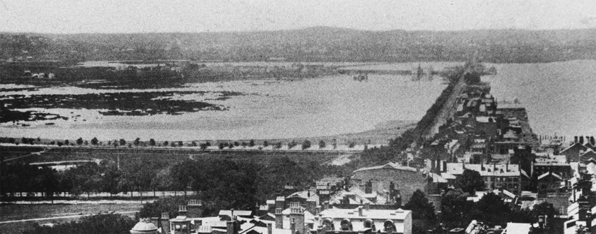
The Common is also an ideal spot to tell an overlooked story of Boston: its radically changed geography. Many people look at the geography of Boston and assume it was always the way it is now. But the landscape you see today is dramatically different than it was 200+ years ago, and Beacon Hill is no exception. So let’s go back for a moment to what this land might have looked like in 1630 when the Puritans first arrived. The place where we started this section of the walk - at the intersection of Beacon and Charles Street - was once waterfront property, formed by a tidal estuary at the mouth of the Charles River. The shoreline of this estuary roughly followed the line of Charles Street all the way to Tremont Street, about a half mile to the south. If you were here in 1630 you would be standing on the edge of water, in the middle of beach grass and mudflats, smelling the salt water and hearing the sounds of the waves and shore birds.

Beacon Hill was one of three hills that existed on the Shawmut Peninsula. These hills included: Copps Hill (the North End), Fort Hill (the Financial District), and Trimountain (Beacon Hill). The later hill - Trimountain - was the highest, with its name deriving from its three separate peaks. In later years Trimountain would be shortened to Tremont, from which we get the name for Tremont Street. The name Beacon Hill actually derives from a signal beacon that was erected on the highest of the summits in this area in 1634 to alert nearby towns of an imminent threat.
Over time the various waterways of Boston were filled in to make more land for a growing population. In this area, this included filling West Cove (1803-1863), which is The Flat of the Hill, and Back Bay (1857-1894), which includes the area west and south of the Boston Common. Some of the other changes included the filling of Mill Pond (1807-1829), South Boston (1836-now), South Bay (1850-now), Fenway (1878-1890), East Boston (1880-now), Logan Airport (1922-now), and more. Mill Pond, which is the location of North Station and TD Garden - where the Boston Celtics and Bruins play - was filled from dirt and gravel taken from the leveling of one of the three peaks of Beacon Hill.
Stop 1: The Tudor
As you walk up the path in the Common that runs parallel to Beacon Street, you will see an eight story red brick building across the street with a stone facade on the first floor. It’s easily recognized by its height and size and the arched windows and doorways on the main floor. This is The Tudor, a massive luxury condominium complex built in Queen Anne style in 1866. This building is on the grounds of the former home of Frederick Tudor, one of the first millionaires in America. Tudor was known locally as the “Ice King.” While visiting the Caribbean as a young man, he realized he could make a fortune exporting ice from his home state to tropical climates. The idea was simple: cut blocks of ice from Massachusetts ponds, pack it in sawdust to minimize melt, and then ship them to warm climates where he could sell the ice for a profit. He eventually added ice houses in the destination countries to store his product longer, and offered a free year's supply to bartenders to get them hooked on his product. The most ingenious part of his idea was that he could acquire his two main ingredients - the ice from ponds and sawdust from mills - for free. It took a few failures and some time in debtors' prison to get his business right, but eventually he became a self-made millionaire, selling ice as far away as India and Hong Kong.
Stop 2: The Gold Dome of the State House
As you walk up the hill you will see the gold dome of the Massachusetts State House ahead to your left. This dome was built of wood and began to leak not long after its construction in 1798. Paul Revere, who is best known in history for his night time ride to warn colonists before the Battle of Lexington & Concord, was asked to cover the dome in copper. This copper roof would later be covered in the 24 karat gold you see today. The only time after this it was not gold was during World War II, when fear of German bombers using this as a landmark caused the state to paint it black.
When you get to the top of the hill, please go up the steps that go to the street across from the State House.
The Development of Beacon Hill
To understand the development of Beacon Hill, it is necessary to understand its two halves: the South Slope, facing the Common where you are now - and the North Slope, which is several blocks on the other side of the hill, facing Cambridge Street. In the 1700s, the first development on the South Slope occurred right here by the Common, which was one of the few buildable areas on the hill. The South Slope would be home to several rural estates, as the wealthy sought to locate themselves on the outskirts of the city. This included Hancock Manor, which was recognized as one of the most beautiful homes in the city.

On the North Slope, a small isolated waterfront community formed in the area of Cambridge Street that became known as West Boston. This community would start as a rough-and-tumble neighborhood with a poor reputation. During the occupation of Boston (1768-1776) in the Revolutionary War, British soldiers referred to the nearby peak located at Louisburg Square as Mount Whoredome. Over the late 18th and first half of the 19th century, the North Slope would become home to African Americans and immigrants from eastern and southern Europe.
In the 1790s, the Massachusetts state government decided to build a new state house. They acquired six acres from the heirs of John Hancock, who had recently passed away. The construction of the State House was started in 1795 and finished in 1798. The architect was a young Boston resident, Charles Bulfinch, who would go on to design many famous buildings in Boston and Washington DC, including the rotunda of the US Capitol. Up until the development of the State House, the area of Trimountain looked much as it had when the Puritans first arrived here 160+ years before - its high peaks making it mostly uninhabited. This was all about to change.
Let’s take a look at some locations while we are at the State House.
Stop 1: Robert Gould Shaw & the 54th Regiment Memorial
To your right directly across the street from the State House is the memorial for the Massachusetts 54th Regiment, one of the first Black units to fight in the Civil War. Their story is told in the 1989 film Glory. The 54th marched down Beacon Street on their way to war, right past the location where you are now standing. They were part of a strong anti-slavery movement that had developed in Boston and was centered in Beacon Hill. We will talk more about the story of African Americans on Beacon Hill shortly. The two scraggly looking trees on either side of the memorial - a result of careful pruning to keep them healthy - are some of the oldest elms in North America at over 230 years old. These trees were planted by none other than John Hancock himself.
Stop 2: The John Hancock House
Let’s cross the street and walk along the sidewalk to the left of the State House. On the fence past the John F. Kennedy statue you will find a plaque commemorating the former location of John Hancock’s house. The Hancock Manor was built by Thomas Hancock in 1737, and was inherited by his wife’s favorite nephew John Hancock. John would become a wealthy merchant, Founding Father, and signer of the Declaration of Independence. If you look at the Declaration of Independence, you will see Hancock’s signature is the largest and clearest - from which we get the phrase “sign your John Hancock.” During the Siege of Boston (1775-1776), the home was ransacked by British soldiers. After the war, Hancock would go on to be governor, and he passed away in 1793. In 1795 the pasture of the Hackcock estate was purchased by Massachusetts for the development of the new State House. The house would continue to be inhabited until it was sold in 1863 and torn down after the state failed to muster support to purchase it. The public outcry from the destruction of this historic home would spur the preservation movement in the city that ensured many other buildings would be saved.
Stop 3: Statues at the Massachusetts State House
While at the State House, look for the statues of Mary Dyer and Anne Hutchinson. Both were early women in Boston who fought back against the strict religious intolerance of the Puritans. Anne was banished from Boston in 1638 after preaching that “good works” could bring God’s grace. Mary was hanged for heresy after proselytizing for her Quaker religion in 1660. The sacrifices of both women would eventually pave the way for religious tolerance in Boston, and for the separation of church and state.
Stop 4: The Beacon Hill Monument
Continue east on Beacon Street and turn left on Bowdoin Street, which will take you around the east wing of the State House. You will pass the 21st Amendment, a common gathering place for state legislators, lobbyists and lawyers. Before you reach Derne Street, you will see a monument of a golden eagle atop a 60 foot stone pillar - which was the height of the original warning beacon that stood on this hill for a century and a half. This is a replica of the monument, but the original was in the same location (1790-1811) but 58 feet higher up on the peak that once resided here. This peak was so steep that it needed to be climbed using both hand and foot holds. The monument was designed by Charles Bulfinch, and commemorated American independence. The dirt and rock from this former peak was used to fill in Mill Pond, which is the current location of TD Garden and North Station.
African Americans in Beacon Hill
From the Beacon Hill Monument, we will turn left onto Derne Street, and follow it across Hancock Street where its name changes to Myrtle. Please take a right onto Joy Street. We will walk down the hill to 67 Joy Street. We will now tell the next story of Beacon Hill: the story of African Americans in Boston. Let’s get started.
The early settlements in the New World were business ventures, funded by shareholders looking for a return on their investment. To maximize profitability, owners initially sought low cost labor from indentured servants - men or women who signed contracts agreeing to work for a specified number of years in return for transportation to the New World. But with white indentured servant labor to the New World in short supply, the early settlers eventually turned to a more barbaric solution: purchasing enslaved people from Africa. While the first enslaved Africans in the United States had some minimal rights - often appearing in early court records to advocate for themselves - these rights were quickly stripped away as owners became dependent on the labor of their slaves. It was not long before slavery would be systemetized into a way of life in the South, and their inhumane treatment normalized across the Colonies.
While there was never a large population of enslaved people in Boston, the Puritans had no moral issues with slavery, believing that as God’s chosen people, they had a right to subjugate others. The first enslaved Africans were brought to Boston in 1638, and not long after Massachusetts would become the first colony to legalize slavery (1641). The Puritans would also enslave Native Americans they captured in war. The founder and governor of Boston, John Winthrop, held enslaved people. In 1644, Boston merchants began to participate in the Triangular Trade, which brought enslaved Africans to the Caribbean in return for bringing sugar back to Boston. The trade created enormous wealth in the city, and made merchants like John Hancock among the wealthiest people in town. In addition, many Bostonians that did not hold enslaved people still profited off the financial opportunities that supported the slave economy - such as outfitting ships and insuring voyages.
Lacking the land for agriculture found in the South, enslaved Africans in Boston were primarily domestic servants and tradesmen. Some would go on to purchase their freedom, and many made the North Slope of Beacon Hill their home. They would be joined over the years by both enslaved people who fled slavery in the South and formerly enslaved people who had been freed. By the end of the 18th century, the North Slope of Beacon Hill would become the primary Black neighborhood of Boston. By the time of the American Revolution, one out of ten residents of Boston were Black.
Over time, the attitudes toward slavery changed in Boston. John Hancock was an example of this change. As a merchant, he profited off the Triangular Trade, bought and sold enslaved people, and had slaves working in his Beacon Hill home until the outbreak of the American Revolution. But after signing the Declaration of Independence, he changed his mind on slavery. As governor, he would abolish slavery in Massachusetts in 1783, and advocated unsuccessfully for doing the same in the US Constitution. By the early 1800s, Beacon Hill would become the epicenter of the abolitionist movement in New England. The state declared trading enslaved people to be illegal in 1788, and made free any enslaved person brought into the state after 1836. In 1855, Massachusetts prohibited school segregation, bringing about the first legal integration of schools in the United States. Beacon Hill was also an active stop on the Underground Railroad, helping enslaved people fleeing slavery to escape to Canada or other parts of the United States. The work of the Underground Railroad became particularly dangerous after the passing of the Fugitive Slave Act in 1850, which exacted harsh punishment on anyone who interfered with the recapture of enslaved people in the United States. Beacon Hill would remain the primary Black neighborhood of Boston until after the Civil War, after which an influx of new immigrants resulted in the gradual migration of African Americans to areas such as South Boston, Roxbury and Dorchester.
We will now look at a few of the important historical locations in the African American story of Beacon Hill.
Stop 1: The Rebecca Lee Crumpler House (67 Joy Street)
Rebecca Lee Crumpler is considered to be the first African American woman doctor. As a nurse, she provided medical care to people released from slavery after the Civil War. She moved to Boston where she earned her degree in 1864 from the New England Female Medical College, which would later become part of the Boston University School of Medicine. Her practice on Beacon Hill focused on women and children, with an emphasis on nutrition and preventive medicine.
Stop 2: 3-10 Smith Court
Let’s backtrack up Joy Street until we come to a street called Smith Court on the right. The five residences you see here were typical African American homes on the North Slope of Beacon Hill in the first half of the 19th century. These homes were built between 1799 and 1830, and were owned or rented by African Americans from all walks of life. Among the many residents that lived here were a hairdresser, a chimney sweep, a historian, a mariner, a clothier and an entrepreneur. They were all part of an active and prosperous Black community on Beacon Hill.
Number 3 was the home of William Nell, the first published African American historian. He was born in Boston, with a father from South Carolina and a mother from Massachusetts. He was a civil rights activist best known for his work leading to the integration of the Massachusetts schools in 1855. To put this accomplishment in perspective, the federally mandated integration of schools in the United States did not occur for another hundred years. Unfortunately, Boston did not stay integrated over the next century, resulting in court-ordered forced busing in the 1970s.
Stop 3: The African Meeting House (8 Smith Court)
The African Meeting House was originally an all Black church erected in 1806. While Black people could attend white churches, they were required to sit in the balconies and had no voting privileges. As a result, the Black community formed their own church here, built entirely by African American labor. This is the oldest Black church in the United States, and was the location of many famous events, including the founding of the New England Anti-Slavery Society by William Lloyd Garrison in 1832, a famous anti-slavery speech by Frederick Douglas in 1860, and the recruiting of the 54th Massachusetts Infantry Regiment by Charles Gould Shaw in 1863. It would also be the center of the community, with weddings, clubs, town meetings and social events all occurring here. The church has since been converted into the Museum of African American History.
Stop 4: The Abiel Smith School (46 Joy Street)
In front of the African Meeting House toward Joy Street is the Abiel Smith School. As the African American community began to form in this area in the late 18th century, they wanted to provide an education for the growing population of children. Since Black children were not allowed into the white public school system, they initially used private homes as schools. Eventually they would centralize their schooling in the lower level of the African Meeting House. As their school grew, they successfully petitioned the city to erect a new school building here in 1835, dedicated to the education of African Americans in Boston. Unfortunately overcrowding, underfunding and shoddy construction of the building, which made it hard to retain teachers at the school. The poor education being received by African American students resulted in increasing dissatisfaction within the community at the dramatic differences between white and Black schools. In 1849, a Black parent filed a suit on behalf of his daughter to allow her to attend a nearby white school. While he would lose the case, the discussion would result in the Massachusetts legislature banning school segregation in 1855.
Stop 5: The George Middleton House (5 Pinckney Street)
We are now going to make our way back up Joy Street toward Pinckney Street. When we get to the intersection of Joy and Pinckney, look at the gray wooden house located at number 5. This house, built in 1787, is the oldest house on Beacon Hill. This was the home of George Middleton, a liveryman who led an all-Black company in the Revolutionary War. One of the lesser known facts of the Revolutionary War is that almost 30,000 African Americans fought on both sides, many of whom were promised their freedom in return for service.
Women of Beacon Hill
We have incorporated the story of the women of Beacon Hill throughout our narrative, but while we are in this area, we will make a few additional stops important to telling their story. The history of Beacon Hill includes many notable women, including a real estate developer responsible transforming this neighborhood in the early 19th century, the founder of one of the first women’s clubs in the country, one of the first female landscape architects, the first African American woman to be admitted to the Massachusetts Bar, the founder of the kindergarten movement in the United States, numerous famous writers and artists, and more.
Stop 1: The Elizabeth Peabody’s Kindergarten (15 Pinckney Street)
Let’s continue down the street until you reach 15 Pinckney Street, the former location of one of Elizabeth Palmer Peabody’s kindergartens. Peabody is considered the founder of the kindergarten movement in the United States, tirelessly advocating for the early education of children. While the building at 15 is not the original, the home at number 17 is a mirror image of the building that once stood here.
Stop 2: The Louisa May Alcott House (20 Pinckney Street)
Louisa May Alcott was an American novelist, abolitionist and feminist best known for her book Little Women, which is loosely based on her childhood experiences living in Concord, Massachusetts. Over her early adulthood, she received education from many famous writers, most of whom were family friends, including Henry David Thoreau, Ralph Waldo Emerson, Nathaniel Hawthorne, Margaret Fuller and Julia Ward Howe. Her writing came from the necessity of keeping herself and her family out of poverty. She lived in a room in this house from 1852 to 1855. She died at the age of 55, likely from mercury poisoning from typhoid fever treatments she received while working as a Civil War nurse.
Stop 3: The Phillips School (65 Anderson Street)
On the way down the hill you will pass Anderson Street. The building at the intersection of Pinckney and Anderson was built in 1824 and served as Boston English High School. Even though it was an all white school, Benjamin Roberts, an African American on Beacon Hill, applied for his daughter to attend this school in the 1840s. When he was rejected, he filed a suit against the Boston School Committee seeking to allow his daughter to go to the nearest school regardless of race. While he lost this suit, changing sentiments resulted in the Massachusetts legislature banning segregated schools in 1855. In the 1870s, Elizabeth Smith would become the first Black teacher in the Boston public school system while working at the Phillips School.
Stop 4: Carly Simon’s House (37 West Cedar)
If you think it must be great to live on Beacon Hill, there is at least one famous singer who might disagree with you: Carly Simon. You likely know Simon for chart topping songs like “You’re So Vain” or “Haven’t Got Time for the Pain.” She bought this home in 1999 shortly after finishing chemotherapy for her cancer. She proceeded to undertake a major renovation that included a new rooftop deck. Shortly after moving in, she opened her windows, sat at her piano and started to sing. A neighbor called the police, who arrived to inform her that singing violated a noise ordinance in Beacon Hill. Next the building inspector found her rooftop deck had to be removed because it was in violation of building codes. And as a final straw: one morning she came down to her kitchen to find rats eating from her fruit bowl. She would go on to sell this home, claiming “chemotherapy paled in comparison to the problems I had with that house.”
Stop 5: The Susan Paul House (36 West Cedar)
Follow Pinckney Street down until it intersects with West Cedar. Take a left on West Cedar and you will be facing one of the more popular Instagram locations in Beacon Hill: Rouvalis Flowers. To the left of the flower shop is 36 West Cedar, which was the home of Susan Paul, a teacher at the segregated Smith School on Joy Street. Paul was a Black woman who in 1835 wrote the first biography of an African American, a story about one of her students that died at age six.
The Iconic Homes of Beacon Hill
From the Susan Paul house at 36 West Cedar, we will continue south a block and a half, crossing over Mount Vernon Street and stopping at Acorn Street.
When the land for the State House was purchased in 1795, it set off real estate speculation on Beacon Hill. Developers purchased open land in the sparsely populated areas on the South Slope, hoping to build homes for wealthy citizens. One of the best known land speculators in this era was the Mount Vernon Proprietors, which purchased and developed 30 acres on the South Slope starting in 1795. While the membership of the Proprietors changed over the years, it included several notable wealthy citizens, including Jonathan Mason, Harrison Gray Otis, Charles Bulfinch and Hepzibah Clarke Swan (the only woman in the partnership). One of their initial land purchases was from the famous American painter John Singleton Copley, who is best known for his portrait paintings of notable people from the Colonial era. You can still see Copley’s works today in the Boston Museum of Fine Arts.
The Mount Vernon Proprietors are responsible for the grid of streets you see today. After purchasing the land, they regraded it to lower the steep peaks by constructing a gravity railroad to haul the dirt away. Rather than remove the dirt from the neighborhood, they used it to fill in the shoreline at the base of the hill, making space for today’s Charles Street. This had the double benefit of providing a road around the western edge of Beacon Hill, while also making new buildable land for the Proprietors to develop. Over three years, the Proprietors flattened the land and built the grid of streets, including the one on which you stand now. The first houses that were built were large freestanding mansions with gardens, stables and carriage houses. But the Proprietors also built double houses - freestanding homes designed for two separate families - and would also erect rows of houses on entire blocks. Within just two decades, Beacon Hill was transformed from a rural cow pasture that was too steep for homes, to a fashionable neighborhood for the well-to-do. It was so fashionable that it was common for wealthy citizens in this era to buy “daughter houses”, which were homes purchased to allow their children to live nearby.
In 1807, President Jefferson issued an embargo on trade with France and Britain, resulting in an economic downturn that halted most of the construction on Beacon Hill. It wasn’t until after the War of 1812 - in the late 1810s - that the second major phase of development of the neighborhood would continue. This next decade would pass the torch to a new set of developers and architects, who would focus more on raising entire blocks of row houses. It was in this era that West Boston - which bordered on the North Slope - would be cleaned up to make it a respectable middle class neighborhood. But this era came to an end with the economic slowdown following the Panic of 1829, which would then be followed by the final phase of rapid development in the 1830s.
By the 1840s, the three phases of development on the hill had made use of almost all the buildable land. You can still see this phased development in the distinct styles of the homes in Beacon Hill today, with Federal-styles dominating during the first two phases, giving way to Greek Revival in the 1830s, some Victorian in the 1840s, and then with flourishes of each style added to different homes over time based on changing fashions and tastes.
We will be looking at houses from each of the phases of development.
Stop 1: Acorn Street
You should be standing at the intersection of West Cedar and Acorn Street. Across from Acorn Street are row houses built in 1827 that provide a great example of an entire block from the second phase of the development on Beacon Hill. These houses were built by Cornelius Coolidge, who is one of the best examples of the emerging dual role of designer-builders. Acorn Street is one of the most photographed streets in the United States. These homes were built in the late 18th and early 19th century, and the cobblestone street gives us a glimpse of what Beacon Hill looked like in the horse and buggy era.
Stop 2: Louisburg Square
Let’s backtrack on West Cedar Street until it intersects with Mount Vernon, and head up the hill. I recommend walking on the left side of the street. A short way up the hill you will see on your left a park surrounded by rows of houses. Welcome to Louisburg Square, one of the most exclusive locations on Beacon Hill. Take a left into the square and walk around the park to return back to Mount Vernon Street. These Greek Revival homes were built in the third phase of development, in the 1830s and 1840s. Some of the famous residents here included Charles Bulfinch, John Singleton Copley, and Louisa May Alcott. This is also the current home of John Kerry, former Secretary of State and presidential candidate, and his wife, Teresa Heinz, the widow to the heir to the Heinz Company. Teresa Heinz was the subject of local controversy in the 1990s after a newspaper published a picture of her car illegally parking in front of a fire hydrant outside her home. But the Secretary and his wife had the last laugh, paying to move the fire hydrant to a new location. Louisburg Square has the oldest homeowners’ association in the United States. Just east of here was the former location of one of the three peaks of Trimountain, which the British soldiers referred to as Mount Whoredome. During the British occupation of Boston in the Revolutionary War, a battery was located on this peak that fired on George Washington’s troops in Cambridge.
Stop 3: The Charles Bulfinch House (87 Mount Vernon Street)
This is a great example of a double home, which was built in 1809 for Charles Bulfinch by the developer-architect Jeremiah Gardner. The house shows examples of accents added to homes over time, with one side in Georgian-style and the other in Greek Revival. The right house is the home of the Colonial Society of Massachusetts, a non-profit dedicated to publishing documents on the Colonial history of the state. The Colonial Society will periodically open the home to visitors for local events such as a Beacon Hill Holiday Wreath Tour.
Stop 4: The Harrison Gray Otis House (85 Mount Vernon Street)
This is the second home built for Harrison Gray Otis, one of the founders of the Proprietors. It was built in 1802, and is one of the best remaining examples of a freestanding mansion on Beacon Hill. This home once had a larger property that included stables in the back. Otis would live in this house for five years before moving to another home on Beacon Street. There are very few remaining freestanding mansions on Beacon Hill, with most demolished by the 1840s to make room for new row houses.
Otis is one of the family names that were known as the Boston Brahmins, members of the city’s upper class in the 19th century, whose families descended from the earliest colonists. The Brahmins were often associated with elite institutions such as Harvard University and the Somerset Club.
This home also has an interesting connection to The Thomas Crown Affair, a 1968 hit movie starring Steve McQueen and Faye Dunaway. You may know this movie better by the 1999 remake starring Pierce Brosnan. The original movie was set in Boston, and tells the story of a millionaire businessman who secretly robs a bank only to be pursued by a determined insurance investigator. Several scenes from the movie were filmed in Beacon Hill, including inside and outside this home.
Ironically this movie inspired a copycat crime. In 1969, a bank teller in Ohio, who was reported to have been obsessed with The Thomas Crown Affair, stole $215K from his employer and promptly disappeared. While the story appeared on the TV crime shows America’s Most Wanted and Unsolved Mysteries, his whereabouts remained unknown. The story would finally be solved in 2021, when documents left to the family of a man who died of lung cancer revealed his true identity. The bank robber had died in a suburb of Boston, just miles from the location of the movie that inspired his crime. It is believed he moved to Boston to be closer to the movie - even living for a time in Beacon Hill.
Stop 5: The Swan Stables (50, 56 & 60 Mount Vernon Street)
These low houses are the former stables for three “daughter houses” that reside on Chestnut Street. The three homes were built in 1805 and 1807 by Hepzibah Clarke Swan, the only woman partner in the Mount Vernon Proprietors. She gave these homes to her daughters on their wedding days. You can still see these three “daughter houses” rising above and behind the homes that now reside at 50, 56 and 60 Mount Vernon Street. The stables have since been turned into houses, and have survived at their current stature due to a 13 foot height restriction in the deed.
Stop 6: 59 Mount Vernon Street
This home is one of the best examples of the 1830s movement toward Greek Revival. It was built in 1837 as one of five homes that were constructed from the demolition of the freestanding mansion of Jonathan Mason. Greek Revival homes are known for being more somber and heavier in their design. It was also common for them to have stone basements that are above the ground and ornate post beam entrances.
Stop 7: The Daniel Webster House (57 Mount Vernon Street)
The home at 57 Mount Vernon Street is one of several row houses here that once belonged to Jonathan Mason. This one was lived in over time by both Daniel Webster and Charles Francis Adams. Webster was a lawyer and statesman who served as secretary of state for three US presidents. Charles Francis Adams was a diplomat, writer, and politician who was the son and grandson of two US presidents (John Quincy Adams, John Adams).
Stop 8: The Nichols House Museum (55 Mount Vernon Street)
This Federal style house was built by the Mount Vernon Proprietors in 1804 from a Charles Bulfinch design. It was one of four houses built on behalf of Jonathan Mason, one of the original founders of the Mount Vernon Proprietors. The museum that now resides here preserves in time the life on Beacon Hill of two generations of the Nichols family, from the late 19th to the early 20th century. This was the home of Rose Standish Nichols, one of the first well-known female landscape architects in the United States. She was a lifelong pacifist who used her home as a salon for promoting international friendship.
Stop 9: The Portia School of Law (45 Mount Vernon Street)
While this is not one of the iconic houses of Beacon Hill, the home at 45 Mount Vernon Street was the former location of the Portia School of Law. The school started in 1908 when two women wanted to take the Massachusetts bar exam. This school grew over time with a focus on providing legal education to women. In 1923, Blanche Woodson Braxton, a graduate of this school, would become the first African American woman admitted to the Massachusetts Bar.
Stop 10: The Somerset Club (42 Beacon Street)
After your stop at the Portia School of Law, continue south on Joy Street until you return to Beacon Street. Take a right on Beacon and walk down the hill. On your right as you walk you will come across a majestic white granite building at 42 Beacon Street, with two curved bays on each end. This house was built in 1819 for Colonel David Sears, and was designed to be a granite version of his father-in-law, Jonathan Mason’s, house. Since 1871 this has been the home of the exclusive Somerset Club, which was often associated with Boston Brahmins. If you find out how to get a membership application, please let me know.
Stop 11: The Third Harrison Gray Otis House (45 Beacon Street)
To the left of the Somerset Club at 45 Beacon Street is one of the remaining freestanding mansions on Beacon Hill. This 1806 house was the third and final home of Harrison Gray Otis, one of the wealthiest citizens in Boston and founder of the Mount Vernon Proprietors. The house was designed by Charles Bulfinch, and is one of only a dozen or so homes still standing that can be directly attributed to him.
Decline & Rise of Beacon Hill
After leaving the Harrison Gray Otis house, continue walking down the hill to the intersection of Charles and Beacon Streets. You will eventually arrive at a Starbucks on 66 Beacon Street.
Starting in the 1850s, the city filled in much of the Charles River Basin to form over 500 acres of new buildable land for a neighborhood called Back Bay. Between 1859 and 1900, the area was developed with rows of Victorian brownstone homes that were larger and more modern than those in Beacon Hill. These homes were arranged along straight European-inspired avenues, with back alleyways to allow for deliveries and access by staff. The homes were built with the latest advances in technology, including central heating, gas lighting and modern plumbing. This development coincided with the gradual dipalidation of Beacon Hill after the Civil War, which drove down the price of real estate and resulted in the conversion of many single family homes into boarding houses. Several other homes were demolished in this era to make room for tenement-style housing, particularly on the North Slope. The low rent prices of the tenements and boarding houses made the neighborhood attractive to working class residents of Boston, including an increasing number of Irish and Jewish immigrants. The Irish in particular - driven to emigrate from their home country by the potato famine of the 1840s - would make the North Slope their homes, displacing over time the African American population that would relocate to other areas of Boston. It was during this era that the slang “bridgets” was adopted in the city to refer to household servants, due to the prevalence of Irish women with this first name. By the late 1880s, many of the wealthiest citizens had moved from Beacon Hill to Back Bay, with the Hill increasingly seen as rundown, cramped and outdated.
Starting in the 1910s, increased neighborhood activism raised awareness of the changes needed to revitalize Beacon Hill. One of the earliest examples of this was a real estate broker named William Codman, who protected homes from tenement developers by purchasing and reselling them to people who were committed to restoring them. This growing activism would result in a transformation of the neighborhood over the next two decades. In 1920, the buildings on the western side of Charles Street were demolished to make room for a wider street. This also would initiate the first redevelopment of the Flat of the Hill, which was then rundown and filled with aging sheds, workshops and garages. The Beacon Hill Civic Association formed in 1922, with the goal of preserving and enhancing the quality of life on Beacon Hill. This group drove several important changes to the neighborhood, including protecting the brick sidewalks, implementing the one-way streets to minimize thru-traffic, and advocating with the state legislature for the Beacon Hill Historic District.
The Beacon Hill Garden Club also was formed during this decade, attracting visitors to the neighborhood with its famous “Hidden Gardens” tour that still operates today. But possibly the most impactful organization was the Beacon Hill Associates, a real-estate group that would build many new properties that added to the distinct charm of the neighborhood. In many ways, the Beacon Hill Associates was the 20th century version of the Mount Vernon Proprietors. We will see a few of their properties at our next stops.
We will now walk through The Flat of Beacon Hill.
Stop 1: 68 Beacon Street
On each side of Charles Street you will see two tall buildings. The Starbucks is located at 66 Beacon Street, and across Charles Street you will see a grayish-brown brick building that is at number 68. This building - known as “The Public Garden Apartments” - is an example of the work of the Beacon Hill Associates. It was completed around 1920, and was intentionally designed to provide a visual balance to the similar building at 66. Together these buildings demarcate the entrance to Beacon Hill.
Stop 2: Hampshire House (84 Beacon Street)
Let’s cross Charles Street at this intersection and walk west on Beacon Street. The Public Garden will be across the street to your left as you walk, and everything to your right is the Flat of the Hill. We will stop briefly at the end of this block at 84 Beacon Street at the Hampshire House. This Georgian Revival mansion was built in 1909 and later turned into a hotel. It is of course best known by people who watched the 1980s sitcom Cheers as the Cheers bar.
Stop 3: Byron Street
Turn right on to Brimmer Street, and then take another right on to Byron Street. The series of lower houses you see on this block are what remains of the stables of Beacon Hill. While the initial freestanding mansions from the early 1800s were designed with their own stables, as the Hill became filled with more row houses, residents put their horses in stables on the Flat of the Hill. These stables would eventually turn into garages with the invention of the automobile in the early 20th century, and some would be used as workshops. The revitalization of Beacon Hill following the 1920s would transform these stables into the homes you see today.
Stop 4: The Witch of Lime Street (10 Lime Street)
Go to the end of Brimmer Street, turn left onto River, cross over Chestnut Street and make another left onto Lime. The terrible death toll from World War I launched a growing interest in spiritualism in the 1920s. One of the most prominent leaders of this movement, Sir Arthur Conan Doyle, the creator of Sherlock Holmes, was convinced psychic mediums could allow communication with the dead. At his urging, the Scientific American created a contest to prove the existence of authentic mediums. This contest would lead a panel of judges to 10 Lime Street, the home of Mina Crandon, the attractive socialite wife of a Boston surgeon. Through numerous séances, Mina demonstrated her powers, which proved convincing to all but the toughest judge on the panel: the famous escape artist Harry Houdini. In the end, while Mina was able to convince some of the judges of her powers, the Scientific American did not award her the prize, and she remained surrounded by controversy until the interest in spiritualism faded in the 1930s.
Stop 5: George Doriot House (12 Lime Street)
This home at 12 Lime Street was the location in 1957 of the first venture capital deal. George Doriot, founder of American Research and Development Corporation, signed a deal to provide $70K to the founders of a startup called Digital Equipment Corporation (DEC). While George had an office in the financial district of Boston, this first deal was signed at his kitchen table. This investment would be worth $35M when DEC went public in 1968.
Stop 6: 30 Lime Street
Continuing down the street you will see 30 Lime Street, another of the properties developed by the Beacon Hill Associates in 1913.
Stop 7: The Sunflower Castle (130 Mount Vernon Street)
Continue to the end of Lime Street, take a right on to Brimmer, and then take a right on to Mount Vernon. Your best view will be from the left side of this street. Follow Mount Vernon until it intersects Charles Street. You will pass the Church of the Advent (1844) on your walk. Before you reach Charles Street, you will reach the Sunflower Castle on your right, which is unlike any other house on Beacon Hill. It was once a simple brick building that was redesigned in 1879 in the Arts and Craft style.
Stop 8: Charles Street Meeting House (70 Charles Street)
Across the street from the Sunflower Castle is the Charles Street Meeting House, which was built in 1807 as a Baptist church, on land that was created when the Mount Vernon Proprietors flattened The Hill. The church was originally located more toward the center of the road, but was moved west when Charles Street was widened in the 20th century as part of its revitalization. In the 1830s, one of the members of the congregation challenged the segregated seating by inviting his Black friends to his pew. He was expelled from the church, and would later go on to join one of the first integrated churches in Boston.
Conclusion of the Tour
This concludes the Historic Boston: Beacon Hill podcast. I hope you enjoyed your tour. While we tried to cover many of the important sites in Beacon Hill, there are simply too many to see in a single walk. I would highly recommend you spend time going up and down Charles Street to get a feel for the main street of the neighborhood, where you will find lots of interesting shops and restaurants. If you want to continue your tour, you can find many great resources online, including the Boston Black Heritage Trail and the Boston Women’s Heritage Trail, both of which give more depth to the diverse stories of this neighborhood. There are also three museums to visit to experience more of this history: the African American Museum and the Nichols House Museum - which are both in Beacon Hill - and the Gibson House Museum in Back Bay.
Thank you and I hope you enjoyed your time in Beacon Hill.